
Location and Regional Setting
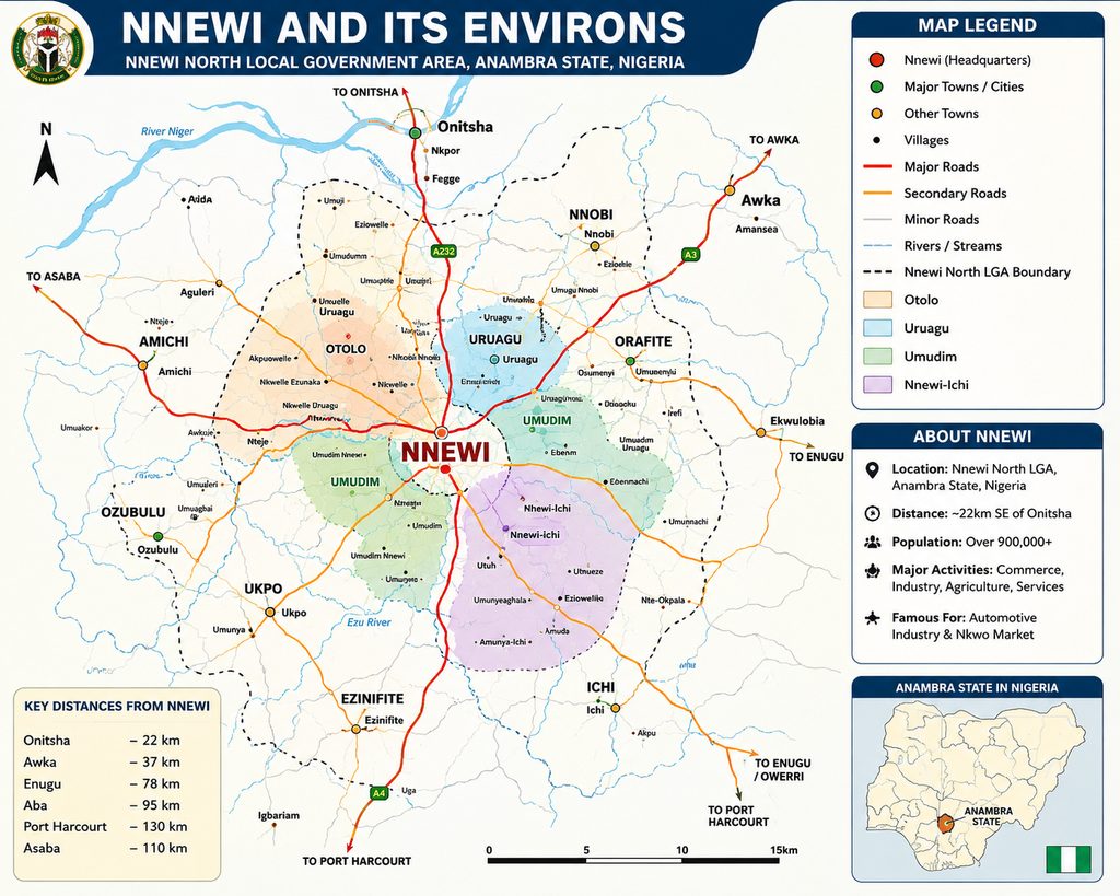
Nnewi is strategically located in Anambra State in southeastern Nigeria and is one of the most important urban, commercial, and industrial centres in the region. The city lies approximately 22 kilometres (14 miles) south-east of Onitsha, one of West Africa’s largest commercial cities, and occupies a central position within the densely populated Igbo heartland.
The city is situated along major transportation corridors that connect southeastern Nigeria to other parts of the country. Nnewi is linked by road to Onitsha, Awka, Enugu, Owerri, Aba, Port Harcourt, and other major urban centres, making it a critical hub for trade, commerce, manufacturing, and regional mobility. Its proximity to the Onitsha commercial axis and access to the River Niger trade routes have historically contributed to its emergence as a major economic powerhouse.
The Nnewi Region
Historically, the old Nnewi Local Division comprised fourteen towns and settlements that shared strong cultural, economic, and historical ties. These include:
- Nnewi
- Nnobi
- Oraifite
- Ichi
- Ozubulu
- Amichi
- Ezinifite
- Ukpor
- Osumenyi
- Ebenator
- Ekwulumili
- Alor
- Nnokwa
- Awka-Etiti
Together, these communities form one of the most densely settled regions in southeastern Nigeria. The area has traditionally been characterized by intensive agricultural activity, vibrant local markets, indigenous manufacturing, and extensive commercial networks that have linked the region to the rest of Nigeria and beyond.
The concentration of settlements around Nnewi has created a continuous urban and semi-urban corridor where farming, commerce, education, healthcare, and industry coexist and support one another.
Physical Geography
Geographically, Nnewi falls within Nigeria’s tropical rainforest zone, a region known for its rich vegetation, moderate elevations, and abundant rainfall. The city lies within the broader Awka–Orlu Uplands, a physiographic region characterized by rolling terrain, low hills, valleys, and gently undulating landscapes.
The area is underlain by sandstone and shale formations that have been shaped over centuries by weathering and erosion. These geological formations have contributed to the distinctive topography of the region, creating a landscape of ridges, valleys, streams, and fertile lowlands.
Nnewi is located near the margins of a plateau that gradually slopes westward towards the River Niger basin. Historically, this geographical position provided natural access to inland and riverine trade routes, linking Nnewi with Onitsha, Aboh, the Niger Delta, and coastal trading centres.
Climate
Nnewi experiences a tropical climate characterized by high temperatures, humidity, and abundant rainfall throughout much of the year.
The city has two principal seasons:
Rainy Season
The rainy season generally extends from March to October and is characterized by:
- Frequent rainfall
- High humidity
- Lush vegetation
- Active agricultural production
Annual rainfall is relatively high, supporting the cultivation of crops and sustaining the region’s rich biodiversity.
Dry Season
The dry season typically lasts from November to February and is marked by:
- Lower rainfall
- Increased sunshine
- Reduced humidity
- The Harmattan season
During Harmattan, dry and dusty winds originating from the Sahara Desert pass across the region, resulting in cooler mornings, hazy conditions, and lower humidity levels.
Soils and Vegetation
Nnewi is located within a lowland rainforest belt that stretches across southern Nigeria. The area was historically covered by dense tropical forest, although urbanization, agriculture, and industrial development have transformed much of the natural vegetation.
The soils of Nnewi are predominantly sandy and lateritic in nature. Due to the region’s high rainfall, some areas experience:
- Soil leaching
- Gully erosion
- Surface runoff
- Land degradation
Despite these challenges, the region remains agriculturally productive and supports the cultivation of:
- Yam
- Cassava
- Cocoyam
- Maize
- Vegetables
- Plantain
- Oil palm
- Fruits and cash crops
The combination of fertile valleys, abundant rainfall, and favourable climatic conditions has historically supported both subsistence and commercial agriculture.
Water Resources
The Nnewi region is blessed with numerous streams, seasonal watercourses, wetlands, and natural drainage systems. These water resources have traditionally supported farming, domestic activities, fishing, and local industries.
Several surrounding communities possess important rivers and wetlands that contribute to the ecological balance of the area. Historically, these waterways also served as local transportation routes and facilitated trade with neighbouring communities.
Urban Development and Land Use
Modern Nnewi has evolved from a traditional agrarian settlement into one of Nigeria’s most important industrial cities. The city’s land use pattern reflects its dual identity as both a cultural centre and a manufacturing powerhouse.
Major land uses include:
- Residential neighbourhoods
- Commercial districts
- Industrial estates
- Educational institutions
- Healthcare facilities
- Traditional markets
- Religious centres
- Agricultural lands
The city’s rapid industrialization has led to the expansion of urban development beyond its traditional boundaries, creating an extensive metropolitan area that continues to grow.
Strategic Importance
Nnewi’s geographical location has played a crucial role in its historical and economic development. Positioned between major commercial centres and connected to both inland and coastal trade routes, the city has long served as a gateway for commerce in southeastern Nigeria.
Its accessibility, entrepreneurial culture, and strategic position within the Igbo hinterland contributed significantly to the growth of markets such as Nkwo Nnewi and the emergence of Nnewi as the automotive manufacturing and spare-parts capital of West Africa.
Today, Nnewi remains one of the most strategically located cities in southeastern Nigeria, serving as a centre for industry, trade, transportation, education, healthcare, and cultural heritage within the region.
Views: 2